Several large fires on the east and west of Deschutes County grew over the last few days, causing evacuation notices for nearby communities.
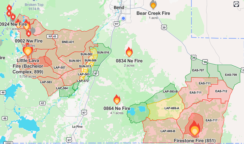
Roughly 30 fires make up the Bachelor Complex Fire on the west side of the county, according to an update from the U.S. Forest Service on Tuesday afternoon, with the Little Lava Fire emerging as “the leader of the gang.”
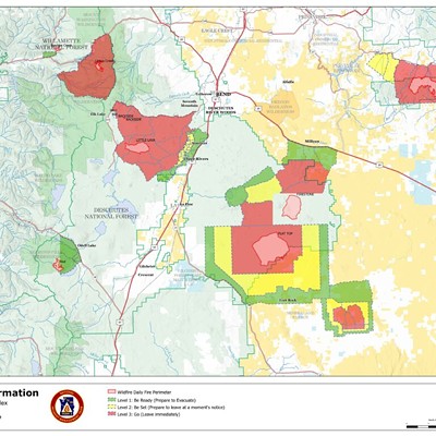
Growth on the Little Lava Fire prompted evacuation level notices for Sunriver and nearby communities. These levels were raised on Tuesday evening with new areas under Level 3 (Go Now) orders, others moved to Level 2 (Be Set) and areas added to Level 1 (Be Ready) extending to Hwy 97. Check the Deschutes County Emergency page for the most up-to-date information.
Roughly 30 fires make up the Bachelor Complex Fire on the west side of the county, according to an update from the U.S. Forest Service on Tuesday afternoon, with the Little Lava Fire emerging as “the leader of the gang.”
Growth on the Little Lava Fire prompted evacuation level notices for Sunriver and nearby communities. These levels were raised on Tuesday evening with new areas under Level 3 (Go Now) orders, others moved to Level 2 (Be Set) and areas added to Level 1 (Be Ready) extending to Hwy 97. Check the Deschutes County Emergency page for the most up-to-date information.
According to the incident report on Tuesday afternoon from Nathan Goodrich, operation section chief for the command incident management team assigned to the Bachelor Complex as well as the Flat Top and Firestone fires on the southeast edge of the county, the team is focusing resources on areas closest to communities.
“A lot of the initial attack resources being smoke jumpers, propellers, local engine crews, that kind of thing,” Goodrich said. “They were very successful in initial attack on the bulk of those incidents.”
Goodrich said that with heavy rain in the forecast, he’s hopeful that the smaller remaining fires will stay contained as resources move to the Little Lava. Current estimates put the fire at 5,758 acres and no containment.
On the southeast edge of the county, the Firestone Fire is burning about 28 miles east of La Pine. The fire is over 10,000 acres with 0% containment and evacuation levels varying around the blaze. Another larger blaze, the Flat Top Fire, is at nearly 27,000 acres and just south of the county line.
“Both of those fires yesterday exhibited pretty good growth on all flanks,” Goodrich said. "And, resources are out there with dozers as well as engines. Hand crews are working along the road prisms, trying to connect to kind of connect the dots a little bit, and kind of stitch some of those things together."
Bachelor Complex Fire evacuation orders as of Tuesday afternoon:
Level 3 (Go Now)
Previous areas: Areas around Mt Bachelor south to Forest Service Rd 40, west of FS Rd 41 (Conklin Rd), and south of FS Rd 4140.
Previous areas: South of FS Rd 40, north of FS Rd 42 (South Century Drive), east of FS Rd 4032, and west of the Deschutes National Forest Boundary.
New areas (previously Level 2): East of FS Rd 45 (River Summit Dr) to FS 41 (Conklin Rd), south of Century Drive, and north of FS Rd 4140.
New areas (previously Level 2): South of FS 40, north of FS 42 (South Century Drive), west of FS Rd 4210, and east of FS Rd 4032.
Level 2 (Be Set)
Level 1 (Be Ready)Previous areas: South of FS Rd 40, north of FS Rd 42 (South Century Drive), east of FS Rd 4032, and west of the Deschutes National Forest Boundary.
New areas (previously Level 2): East of FS Rd 45 (River Summit Dr) to FS 41 (Conklin Rd), south of Century Drive, and north of FS Rd 4140.
New areas (previously Level 2): South of FS 40, north of FS 42 (South Century Drive), west of FS Rd 4210, and east of FS Rd 4032.
Level 2 (Be Set)
Previous areas: Including the Deschutes National Forest east of FS Rd 41 (Conklin Rd), west of the Deschutes River, north of FS Rd 40/Spring River Dr and south of Benham Falls. Excluding private property, which is Level 1 (Be Ready).
New areas (Previously Level 1): Sunriver and areas north of Spring River Rd (FS Rd 40) such as Besson Rd area and Spring River Acres.
New areas: East of the Deschutes National Forest boundary south of Spring River Rd (FS Rd 40) south to South Century Dr (FS Rd 42) including River Meadows, Stage Stop Meadows, and Deschutes River Recreational Homesites.
Previous Areas: West of the Deschutes River from Fall River Estates north to Spring River Rd, including Fall River Estates, and River Forest Acres.
New areas: West of Hwy 97 south of Lava Butte and adjacent to Sunriver, south to Vandervert Rd including the Sunriver Business Park, Caldera Springs, Crosswater and Vandervert Ranch.
New areas: Oregon Water Wonderlands and Big River Drive area north of South Century Dr (FS Rd 42).
New areas: West of Hwy 97 south of Lava Butte and adjacent to Sunriver, south to Vandervert Rd including the Sunriver Business Park, Caldera Springs, Crosswater and Vandervert Ranch.
New areas: Oregon Water Wonderlands and Big River Drive area north of South Century Dr (FS Rd 42).
Firestone Fire evacuation orders remain the same from our previous reporting. This story will be updated as conditions change. This article was corrected to reflect current levels.


![Race for Deschutes County Sheriff Heats Up ▶ [With Video]](https://media2.bendsource.com/bend/imager/race-for-deschutes-county-sheriff-heats-up/u/r-bigsquare/21832439/news2-1-ab920340a63d5120.jpg?cb=1726161706)