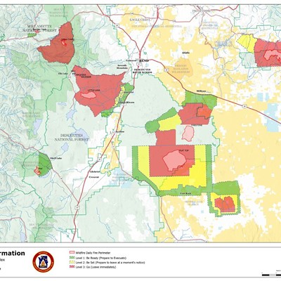
New fires in the Deschutes National Forest caused evacuation notices and closures near Mt. Bachelor and in Southern Deschutes County and northern Lake County.
As of 3pm on Sun., Sept. 8, evacuation notices were in place for the Backside Fire, located west of Mt. Bachelor, and the Firestone Fire, located south of Pine Mountain, near the Lake County line.
The Backside Fire was first reported at 10am on Saturday, Sept. 7. At noon on Sunday, the Backside Fire was 80 acres. Multiple air and ground resources are responding, according to a Central Oregon Fire Info.
A Level 3 "Go Now" Evacuation was issued for Mt. Bachelor and surrounding areas including Sparks Lake, Devils Lake, Todd Creek Horse Camp, Quinn Meadow and associated trail systems. A complex Incident Management Team has been ordered to take over command of this fire on Sept. 9.
Due to the continued growth of another fire near Mt. Bachelor, The Little Lava Fire, the Deschutes County Sheriff's Office updated evacuation areas on Sept. 9. The Little Lava Fire, south of the Backside Fire, reached 1000 acres Sunday night.
A Level 3 "Go Now" was issued for south of the current Level 3 evacuation areas to FS Road 40, west of FS Road 45 (River Summit Drive) and east of FS Road 4270, Cascade Lakes Highway, and Lava Lake Area. This area also includes Sheridan Mountain, Wake Butte and surrounding areas.
The Firestone Fire was reported on Sept. 6 and grew to about 6,854 acres by 3pm on Sept. 8.
Evacuation areas for the Firestone Fire as of 2pm on Sunday:
Level 3 (GO Now): Pine Mountain and areas south to the Lake County Line. Additionally, areas west of FS 18 Rd (China Hat Rd) south of FS Rd 21 to the Lake County Line.
Level 2 (Be Set): Area north of FS Rd 21 to FS Rd 1835 between Newberry Caldera and FS Rd 18 (China Hat Rd).
Level 1 (Be Ready): Areas within the Newberry Caldera (East and Paulina Lakes), areas north of FS 1835 to FS Rd 1830 and west of FS Rd 18 (China Hat Rd), and the Millican Valley due north of Pine Mountain to Hwy 20.
Another fire near Mt. Bachelor, the Little Lava Fire, was burning on 1,000 acres as of Sept. 8.
In the Willamette National Forest were two more large fire complexes as of Sunday night, including the North Willamette Complex at 4,631 acres and the South Willamette Complex fires at 21,858 acres. One of the fires in that complex is the Boulder Creek Fire east of McKenzie Bridge, which prompted Level One "Be Ready" evacuation notices as of Sunday evening. Level One evacuation notices include areas north of McKenzie Highway from the East end of Drury Ln. East to Old Clear Lake Cutoff Loop.
The Deschutes County Sheriff’s Office is supporting firefighters responding to or engaged with new fires. Central Oregon received multiple lightning strikes from storms over the last 48 hours, crews reported. Firefighters on the Bend-Fort Rock Ranger District of the Deschutes National Forest responded to at least 15 wildfires, mainly clustered near the Mt. Bachelor Roadless Area and the eastern edge of Flat Top Butte and East Butte, according to Central Oregon Fire Info.
As of 3pm on Sun., Sept. 8, evacuation notices were in place for the Backside Fire, located west of Mt. Bachelor, and the Firestone Fire, located south of Pine Mountain, near the Lake County line.
The Backside Fire was first reported at 10am on Saturday, Sept. 7. At noon on Sunday, the Backside Fire was 80 acres. Multiple air and ground resources are responding, according to a Central Oregon Fire Info.

A Level 3 "Go Now" Evacuation was issued for Mt. Bachelor and surrounding areas including Sparks Lake, Devils Lake, Todd Creek Horse Camp, Quinn Meadow and associated trail systems. A complex Incident Management Team has been ordered to take over command of this fire on Sept. 9.
Due to the continued growth of another fire near Mt. Bachelor, The Little Lava Fire, the Deschutes County Sheriff's Office updated evacuation areas on Sept. 9. The Little Lava Fire, south of the Backside Fire, reached 1000 acres Sunday night.
A Level 3 "Go Now" was issued for south of the current Level 3 evacuation areas to FS Road 40, west of FS Road 45 (River Summit Drive) and east of FS Road 4270, Cascade Lakes Highway, and Lava Lake Area. This area also includes Sheridan Mountain, Wake Butte and surrounding areas.
The Firestone Fire was reported on Sept. 6 and grew to about 6,854 acres by 3pm on Sept. 8.
Evacuation areas for the Firestone Fire as of 2pm on Sunday:
Level 3 (GO Now): Pine Mountain and areas south to the Lake County Line. Additionally, areas west of FS 18 Rd (China Hat Rd) south of FS Rd 21 to the Lake County Line.
Level 2 (Be Set): Area north of FS Rd 21 to FS Rd 1835 between Newberry Caldera and FS Rd 18 (China Hat Rd).
Level 1 (Be Ready): Areas within the Newberry Caldera (East and Paulina Lakes), areas north of FS 1835 to FS Rd 1830 and west of FS Rd 18 (China Hat Rd), and the Millican Valley due north of Pine Mountain to Hwy 20.
Another fire near Mt. Bachelor, the Little Lava Fire, was burning on 1,000 acres as of Sept. 8.
In the Willamette National Forest were two more large fire complexes as of Sunday night, including the North Willamette Complex at 4,631 acres and the South Willamette Complex fires at 21,858 acres. One of the fires in that complex is the Boulder Creek Fire east of McKenzie Bridge, which prompted Level One "Be Ready" evacuation notices as of Sunday evening. Level One evacuation notices include areas north of McKenzie Highway from the East end of Drury Ln. East to Old Clear Lake Cutoff Loop.
The Deschutes County Sheriff’s Office is supporting firefighters responding to or engaged with new fires. Central Oregon received multiple lightning strikes from storms over the last 48 hours, crews reported. Firefighters on the Bend-Fort Rock Ranger District of the Deschutes National Forest responded to at least 15 wildfires, mainly clustered near the Mt. Bachelor Roadless Area and the eastern edge of Flat Top Butte and East Butte, according to Central Oregon Fire Info.
—This story will be updated as evacuation orders change.