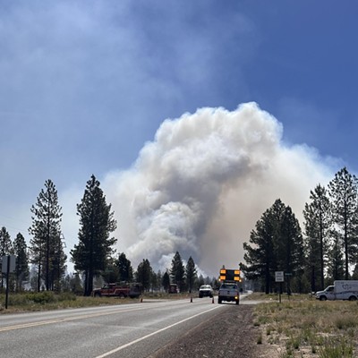
As of noon on Wednesday, the La Pine Darlene 3 Fire, located east of town near Darlene Way and Ice Cave Road, was about 2,415 acres and 30% contained. Firefighters worked overnight to establish control lines around the fire perimeter. According to a press release, winds and warm temperatures Wednesday afternoon will test established lines.
Evacuation areas as of Noon on Wednesday:
LEVEL 2 BE SET EVACUATIONS: The area east of Hwy 97 south of Bassett Dr between the train tracks.
LEVEL 1 BE READY EVACUATIONS: The area west of Hwy 97 north of Burgess Rd., east of the little Deschutes River and south of Riverview Dr.
The focus on Wednesday was to keep the fire within its current footprint and strengthen the lines with dozers, hand crews and engines. Air resources will also continue to engage with the fire as needed.
The Deschutes County Sheriff’s Office had level 2 "Be Set" and level 1 "Be Ready" evacuations in place near the fire.

Evacuation areas as of Noon on Wednesday:
LEVEL 2 BE SET EVACUATIONS: The area east of Hwy 97 south of Bassett Dr between the train tracks.
LEVEL 1 BE READY EVACUATIONS: The area west of Hwy 97 north of Burgess Rd., east of the little Deschutes River and south of Riverview Dr.
The focus on Wednesday was to keep the fire within its current footprint and strengthen the lines with dozers, hand crews and engines. Air resources will also continue to engage with the fire as needed.
The cause of the fire is still under investigation. The Red Cross is staffing the evacuation shelter at the high school, with additional support from the Deschutes County Medical Reserve Corps.
The La Pine Activity Center has space for RVs to park and for animals. The La Pine Rodeo Grounds is accepting livestock and companion animals, in coordination with the Pet Evacuation Team, and Bend Pet Resort is accepting cats and dogs.
The La Pine Activity Center has space for RVs to park and for animals. The La Pine Rodeo Grounds is accepting livestock and companion animals, in coordination with the Pet Evacuation Team, and Bend Pet Resort is accepting cats and dogs.
Campgrounds in the area are also closed. From Central Oregon Fire Info:
"Prairie Campground, McKay Crossing Campground, Ogden Group Campground, and the Rosland OHV play area and associated trails are also closed. The Prineville District Bureau of Land Management (BLM) has also issued an Emergency Public Land Closure. The closure includes all BLM-administered lands within National Forest Road 180 on the south, Highway 97 on the west, Paulina Lake Road on the north, and the Deschutes National Forest Boundary on the east. This closure is effective immediately and will remain in effect until such a time as conditions allow for safe use of the public lands."
"Prairie Campground, McKay Crossing Campground, Ogden Group Campground, and the Rosland OHV play area and associated trails are also closed. The Prineville District Bureau of Land Management (BLM) has also issued an Emergency Public Land Closure. The closure includes all BLM-administered lands within National Forest Road 180 on the south, Highway 97 on the west, Paulina Lake Road on the north, and the Deschutes National Forest Boundary on the east. This closure is effective immediately and will remain in effect until such a time as conditions allow for safe use of the public lands."