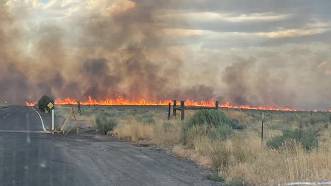
Destructive thunderstorms rolled through Central Oregon over the weekend causing over a dozen new fire starts and rolling back containment efforts on some larger blazes in the region. And, high temperatures and dry weather over the next few days could lead to an increase in fire activity and a heightened chance of new outbreaks, according to Central Oregon Fire Info.

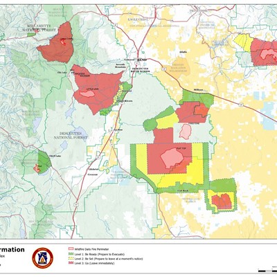
In Jefferson County, northwest of Madras, the Elk Lane Fire started on Sunday following a lightning storm and gusty winds. It's the largest of the new starts and still growing. As of the most recent update on Tuesday afternoon, the fire is reported at 5,093 acres and is a few miles northwest of Madras. Governor Tina Kotek invoked the Emergency Conflagration Act for the fire on Monday afternoon allowing the state fire marshall to mobilize resources to protect communities in the fire's path.
“Winds are starting to pick up. We are trying to bring in additional resources,” Jefferson County Sheriff’s Office wrote on a Facebook update. “Planes will be dipping in and out of Lake Simtustus all day. Please avoid the area to make sure they can safely dip in for water!”
A temporary evacuation shelter is open at Madras High School
with support from the Red Cross and Jefferson County Fairgrounds is being
used for evacuated animals.
The following evacuation orders remain
in effect as of Tuesday afternoon:
Level 3 (Go Now): SW 17, SW 16, NW 5, NW 10, NW 9
Level 1 (Be Ready): NW 12, NW 7, SW 23, SW 23
The following roads are closed due to the fire:
Intersection of Mountain View and Round Butte
Clackamas between Dogwood and Birch
Intersection of Dogwood and Clackamas
Jefferson County Sherriff's Office asks that the public call 458-206-1745 for updates on the fire or to report fire-related activity.
The Mile Marker 132 fire first reported on Friday afternoon in North Bend led to evacuations and a strong air and ground attack from firefighters throughout the evening. As of Monday, the fire was reported at 78 acres. Per the Deschutes County Sheriff’s office the following evacuation levels remain:
Level 3 (Go Now): Juniper Ridge areas east of the Burlington Northern Santa Fe Railroad tracks, north of the city limits to the COID power generation facility.
Level 2 (Be Set): None
Level 1 (Be Ready): The east side of Hwy 97 from the city limits north to Beechcraft Ln (private drive) and west of the Burlington Northern Santa Fe Railroad tracks. Residential north of Cooley Rd. between NE 18th St and Hwy 97NE 18th, Talus Place, and residents along the west side of Deschutes Market Rd.
This story will be updated.


![Race for Deschutes County Sheriff Heats Up ▶ [With Video]](https://media2.bendsource.com/bend/imager/race-for-deschutes-county-sheriff-heats-up/u/r-bigsquare/21832439/news2-1-ab920340a63d5120.jpg?cb=1726161706)